Fast-tracked insights: Tropical Cyclone Alfred
Apr 2025
From the moment a major event like Ex-Tropical Cyclone Alfred hits the radar, the Nearmap ImpactResponse capture program is ready for action – providing a reliable Australian source of high-resolution post-disaster insights for insurers.
Apr 2025
)
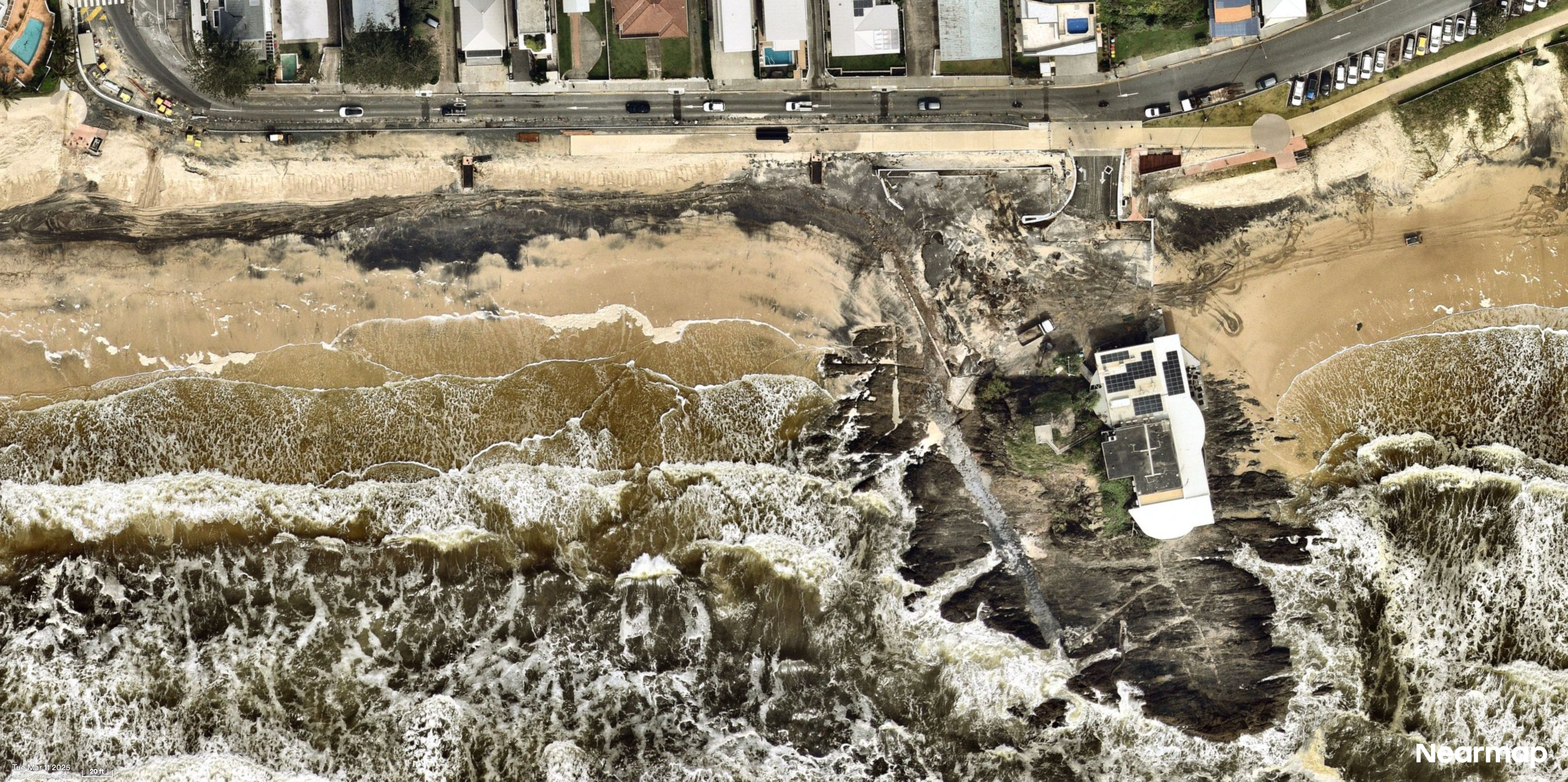
Thu Mar 13, 2025 – Currumbin, QLD
When the Nearmap Geospatial Content Operations (GCO) team began receiving alerts in February 2025 that a tropical low was developing in the Coral Sea, the team closely monitored developments, keeping a close eye on multiple information sources.
By the time the system was officially named Ex-Tropical Cyclone Alfred and classified as a category 1 cyclone, all systems were engaged.
By the time the system was officially named Ex-Tropical Cyclone Alfred and classified as a category 1 cyclone, all systems were engaged.
The GCO team, responsible for planning and implementing flight maps to collect imagery for the Nearmap ImpactResponse post catastrophe program, was ready to launch flights as soon as required.


Urangan, QLD
What does it take to prepare for ImpactResponse image captures?
“My first concern is to balance out the information available,” said M’Shenda Turner, Senior Director of Survey and Geospatial Content Operations in Australia and New Zealand. “To do that, we use a combination of platforms and sources – even social media community pages can be useful to help us understand what’s happening in specific areas, in real time.”
This methodical approach also includes analysing information from multiple sources, including the Australian Government Bureau of Meteorology, MetCentre Weatherwatch Imagery, the Global Disaster Alert and Coordination System, Windy, news media, and more.
Equipped with the relevant information, the GCO team used the marker tool in MapBrowser to pin weather warning points on the map and track Ex-TC Alfred, applying different coloured markers to show points of interest – such as where the cyclone is likely to cross land, major road closures, open evacuation centres, evacuation orders already in place, and reports of confirmed damage.
In ordinary circumstances, Nearmap only flies aircraft to collect location intelligence and imagery in clear conditions. But in the event of a disaster, the GCO team looks for all opportunities to get planes airborne as quickly as possible, even if some clouds remain visible.

Currumbin, QLD
What are the barriers to collecting ImpactResponse data?
“To capture imagery we need clear and stable skies – although we will attempt to capture even if there is patchy cloud at least as a first pass if we can. With an event like Tropical Cyclone Alfred that involves heavy rainfall, cloud cover makes planning even more complicated, requiring contingency plans,” said M’Shenda Turner.
In the lead-up to Ex-Tropical Cyclone Alfred, the GCO team positioned aircraft as close as possible to the impact zone, including one aircraft certified to fly at lower-than normal altitudes in case there was an opportunity to fly beneath the cloud layer, along with regular aircraft that capture imagery at up to 20,000 ft altitude.
In addition to monitoring weather conditions and cloud cover, the Nearmap GCO team also works closely with Air Traffic Controllers (ATC) who are under intense pressure, dealing with excessively high demands and competing priorities in the aftermath of an event like Ex-Tropical Cyclone Alfred.
By Saturday 8th March 2025, when Ex-Tropical Cyclone Alfred made landfall at Moreton Island as a category 1 cyclone – subsequently downgraded to a tropical low on Sunday 9th of March – the Nearmap GCO team was updating flight plans on an hour-by-hour basis. Continuous rain and cloud cover as low as 1,000 ft meant aircraft remained on the tarmac.
By Tuesday 11th March, three days after the tropical low had made landfall, patchy areas of clear skies gave the Nearmap GCO team the go-ahead for take-off clearance, surveying some of the impacted areas.
To enable this, the GCO team had preplanned some aircraft movement, while ensuring that aircraft were not in any impact zones, nor at any airport likely to close down, and that there would be access to aviation fuel, which can be in short supply, especially in periods of high demand like in the aftermath of Ex-Tropical Cyclone Alfred.
In consultation with local councils and authorities to clarify the areas of greatest need for imagery, Nearmap completed 13 separate survey regions from Tuesday 11th to Saturday 15th of March, covering nearly 4000 square kilometres, with three aircraft capturing data.


Alexandra Headland, QLD
As cloud cover continued to clear, Nearmap captured (and re-captured) more areas, including Hervey Bay, the Gold Coast shoreline, Tweed Heads, the Sunshine Coast and Moreton Island.
Even though the impact of Ex-Tropical Cyclone Alfred was not as severe as expected due to its downgrade to a tropical low, Nearmap fulfilled the need to collect and provide ImpactResponse imagery ready to help insurers, responders, recovery teams, and local councils better understand the situation on the ground.
Although at the time of writing it is still too early to know what the final costs will be from Ex-Tropical Cyclone Alfred, the Insurance Council of Australia reported that up to 17th March 2025, Australian policyholders had already lodged 63,600 insurance claims.


Currumbin, QLD
With increasing severe weather events on the horizon, the Nearmap Geospatial Content Operations team is ready to act, bringing insights to insurers in the most crucial moments. Will you be there with us?